
Les services de photogrammétrie permettent de transformer des espaces physiques en représentations numériques précises. Ils assurent la production de nuages de points 3D détaillés, fournissant des données fiables pour soutenir la modélisation, l’analyse et la prise de décision à différentes étapes des projets.


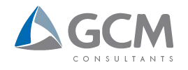

La photogrammétrie regroupe des méthodes avancées de capture permettant de documenter avec précision les caractéristiques d’un site. Réalisée par drone, elle constitue une approche efficace de cartographie aérienne pour la collecte de données géospatiales complètes. Ce processus permet de générer des nuages de points 3D détaillés, essentiels à l’arpentage moderne, à la modélisation et à la création de représentations numériques fidèles.
La cartographie par drone permet une acquisition de données précise et fiable, adaptée aux exigences des projets techniques. Les nuages de points géoréférencés constituent une base solide pour la réalisation de levés photogrammétriques et la production de nuages de points topographiques détaillés. Ces données soutiennent l’analyse, la modélisation et la prise de décision.
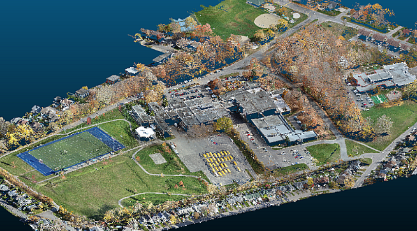
Nos services incluent la production complète d’ortho-images offrant un contexte visuel clair. Nous produisons également des modèles numériques d’élévation (MNE) essentiels à l’analyse du terrain. Les données générées soutiennent une modélisation approfondie et améliorent la compréhension globale du site pour les projets d’ingénierie et d’aménagement.
Les solutions proposées permettent de documenter avec précision l’état et l’avancement des travaux au moyen d’une cartographie détaillée et de relevés 3D structurés. La numérisation de sites patrimoniaux fait également partie des applications, offrant une documentation fidèle et illustrant la polyvalence des technologies modernes de capture de la réalité.
Appuyez vos projets sur une information précise et à jour. Accédez aux données, à l’imagerie et aux quantités lorsque requis, à partir de vos outils habituels. Cette approche contribue à améliorer la sécurité sur les sites, à maintenir une documentation rigoureuse et à soutenir une gestion de projet efficace.
Recevez des images aériennes haute résolution, en continu et géoréférencées, directement exploitables dans les applications SIG. Elles offrent une vue d’ensemble claire du site et soutiennent efficacement la planification des projets, la coordination des équipes et la prise de décision, à chaque étape du mandat.
Obtenez des modèles numériques d’élévation (MNE) du terrain naturel pour une analyse topographique précise. Les modèles numériques de surface (MNS) intègrent les bâtiments et la végétation. Ensemble, ils soutiennent une modélisation complète et fidèle du terrain.
Nous livrons des nuages de points 3D à haute densité, composés d’un grand nombre de points par unité de surface ou de volume. Ces données permettent une représentation précise des formes et constituent une base solide pour l’analyse spatiale détaillée et la modélisation avancée des sites complexes.
L’analyse volumétrique permet d’obtenir des mesures fiables et détaillées des quantités. Les rapports produits soutiennent la gestion des actifs et facilitent le suivi précis des stocks, contribuant à la planification des opérations et à la prise de décision.
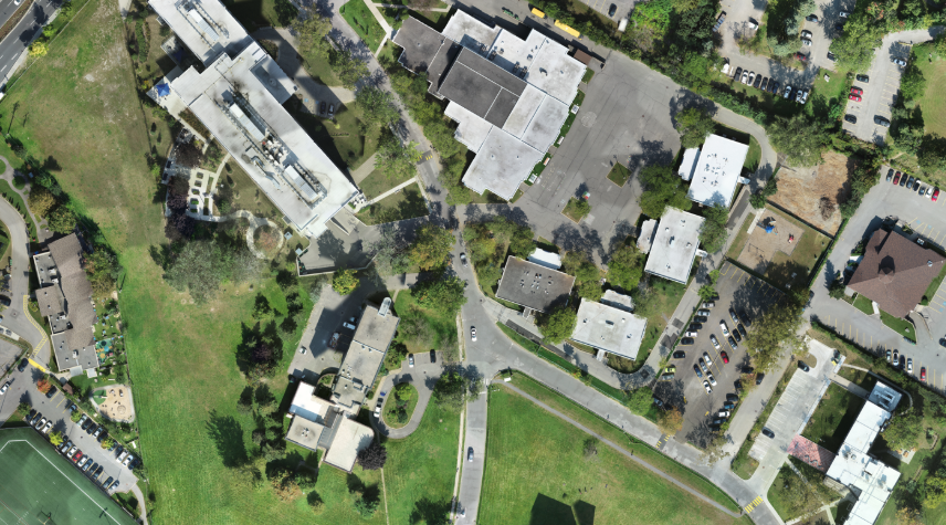
Découvrez des représentations 3D réalistes et interactives, adaptées aux présentations techniques. Elles s’intègrent également aux environnements de réalité virtuelle et augmentée (RV/RA), incluant des nuages de points prêts pour les usages BIM.
Les livrables sont fournis dans des formats compatibles avec vos outils logiciels. Ils peuvent être utilisés directement dans les plateformes SIG (ex. : .shp) et CAO (ex. : .dxf), assurant une intégration harmonieuse à vos outils et méthodes de travail.

Les services de photogrammétrie utilisent des photographies captées sous différents angles pour créer des modèles ou des cartes 3D détaillés. La cartographie précise des sites constitue l’une des applications les plus courantes de cette technologie.
La génération de nuages de points 3D repose sur l’analyse d’images captées sous différents angles, dont certaines portions apparaissent sur plusieurs images à la fois. À l’aide de logiciels spécialisés, les points correspondants sont identifiés afin de calculer leur position dans l’espace. Cette méthode permet d’obtenir une représentation 3D dense et précise du site ou de l’objet analysé.
La photogrammétrie par drone permet une acquisition rapide de données sur de vastes superficies. Elle améliore la sécurité en limitant les interventions directes sur le terrain et constitue une solution efficace et économique pour de nombreux besoins de relevés et d’analyses.
Oui. Les nuages de points fournis sont structurés et compatibles avec les environnements BIM. Ils peuvent être intégrés directement aux logiciels de modélisation du bâtiment, facilitant les processus de conception, de coordination et de réalisation des projets.
La précision des levés photogrammétriques dépend des objectifs et des spécifications du projet. Elle peut atteindre l’ordre du centimètre grâce à la mise en place de points de contrôle au sol et à des conditions d’acquisition et de traitement des images maîtrisées.
Optimisez vos projets grâce à des services de photogrammétrie spécialisés. Obtenez des informations exploitables à partir de nuages de points 3D précis. Notre équipe propose des solutions adaptées, allant de la cartographie aérienne à la reconstruction de surfaces complexes, selon les besoins spécifiques de chaque projet.
Nous utilisons des cookies pour améliorer votre expérience. Choisissez les cookies que vous autorisez :