
Les relevés volumétriques réalisés par drone permettent d’établir avec précision les quantités de matériaux présents sur un site. Ces données soutiennent la planification des travaux ainsi que l’exécution des interventions dans des conditions sécuritaires et efficaces.


Les mesures et calculs volumétriques par drone offrent une précision élevée, adaptée aux exigences des projets actuels. L’étude volumétrique par drone constitue le cœur de ce service et repose sur l’utilisation de véhicules aériens sans pilote (UAV) performants. Nous produisons des données précises qui soutiennent directement la réussite des projets. L’évaluation des volumes de stocks par drone permet d’appuyer la gestion des inventaires dans des secteurs tels que l’exploitation minière, la construction et l’agriculture.
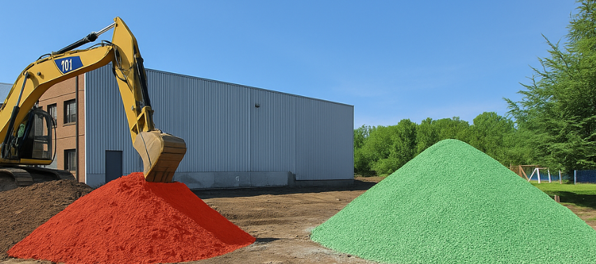
Les drones captent de nombreuses images aériennes superposées des piles de matériaux, ensuite traitées par des logiciels spécialisés. Le traitement photogrammétrique génère un modèle volumétrique précis du site, obtenu par comparaison avec une surface de référence, permettant une estimation fiable des volumes et une analyse cohérente des conditions existantes.
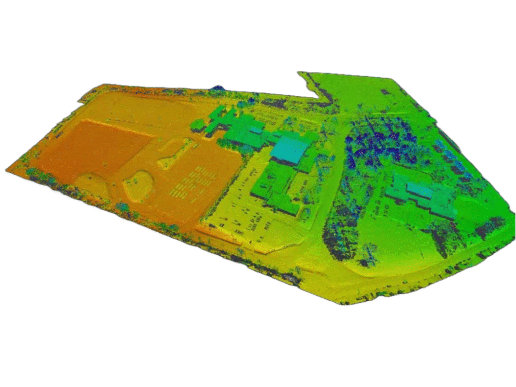
Le LiDAR est particulièrement adapté aux terrains complexes, notamment en présence de végétation dense, puisqu’il permet d’atteindre le sol. Les relevés volumétriques par drone intégrant cette technologie génèrent des nuages de points denses, permettant des calculs précis de déblais, de remblais et des mesures de terrassement pour divers projets.
Des points de contrôle au sol (GCP) sont utilisés afin d’assurer une précision élevée des relevés. Ces points, clairement identifiés et géoréférencés, servent de références pour le positionnement des données. Leur intégration permet d’atteindre une précision RTK de l’ordre du centimètre lors des opérations de cartographie et d’analyse volumétrique par drone.
Nos services permettent d’obtenir rapidement des informations pertinentes et d’optimiser l’utilisation des ressources. L’analyse volumétrique aérienne fournit des données exploitables qui soutiennent la prise de décisions éclairées pour les secteurs de l’exploitation minière, des carrières et sablières, et de la construction.
Réduisez significativement le temps requis sur le terrain grâce aux levés par drone. Mesurez rapidement de vastes zones et des stocks de matériaux. Beaucoup plus rapide que les méthodes traditionnelles, cette approche optimise le suivi volumétrique et facilite une surveillance régulière.
Bénéficiez d’une précision centimétrique grâce à la technologie RTK/PPK. L’utilisation de points de contrôle au sol (GCP) précis dans nos relevés par drone permet de limiter les erreurs lors de l’évaluation des volumes de matériaux en vrac.
Recevez des modèles volumiques 3D détaillés et des rapports complets, conçus pour appuyer des décisions stratégiques. Ces données exploitables facilitent l’analyse du transport de matériaux par drone et la gestion des stocks, en comparant les relevés aux données de conception.
Assurez la sécurité de votre personnel en réduisant les risques sur site. Les drones accèdent aux zones dangereuses ou difficiles d’accès, ce qui élimine les risques associés aux mesures manuelles des stocks et limite l’exposition du personnel aux environnements contraignants.
Réduisez les coûts globaux des projets grâce à des levés par drone plus rapides. La diminution du temps terrain réduit les coûts de main-d’œuvre et d’équipement, tandis qu’une cartographie précise des piles de matériaux optimise l’affectation des ressources.
Suivez efficacement l’évolution du site et les changements dans le temps. Comparez les données volumétriques actuelles issues des relevés par drone aux levés précédents et surveillez l’évolution des stocks et du site grâce à une cartographie de précision.

Un relevé volumétrique par drone consiste à capter des données aériennes qui sont ensuite utilisées pour calculer des volumes. Il est couramment appliqué à l’analyse de piles de stockage, aux travaux de terrassement et aux opérations minières.
La précision est de l’ordre du centimètre. Grâce à l’utilisation des technologies RTK/PPK et de points de contrôle au sol (GCP) positionnés avec précision, les relevés volumétriques par drone offrent des mesures fiables et adaptées aux inventaires de matériaux.
De nombreux secteurs tirent parti de ces services. Ils sont notamment utilisés en exploitation minière, en construction et en agriculture. Les carrières et les producteurs de matériaux granulaires s’appuient également sur les relevés par drone pour les mesures de terrassement et le suivi des volumes.
L’acquisition des données par drone est rapide. Les premiers résultats et les rapports volumétriques peuvent généralement être produits dans un délai de 24 à 48 heures. Le délai exact dépend toutefois de l’ampleur et de la complexité du projet.
Nous fournissons des rapports volumétriques complets issus des relevés par drone. Les livrables incluent des modèles 3D détaillés et des nuages de points précis. Les données peuvent être intégrées à vos plateformes SIG ou BIM existantes.
Nos services de mesure et de calcul volumétrique par drone combinent rapidité, précision et sécurité pour satisfaire aux exigences de vos projets. Faites confiance à notre expertise pour répondre à vos besoins en matière de contrôle des inventaires de matériaux et de production de rapports volumétriques fiables et exploitables.
Nous utilisons des cookies pour améliorer votre expérience. Choisissez les cookies que vous autorisez :